Field activity #7 was a combination of 2 separate classes focusing on 2 different surveying techniques and tools to create a topographical survey. Our class utilized a dual-frequency GPS the first week and a Total Station the second week. These devices are both survey grade units. We will be comparing the accuracy and the useability between them.
Dual-Frequency GPS
TopCon HiPer SR, TopCon Tesla, and a MiFi are three parts/devices to the dual-frequency GPS we will be using in this exercise. To achieve the accuracy the units are capable of all the components must be used together.
The TopCon HiPer SR unit is a GPS receiver/antenna (Fig 1). The TopCon has a static horizontal accuracy of approximately 3mm and a static vertical accuracy of approximately 5mm.
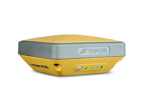 |
| (Fig. 1) TopCon HiPer SR |
The TopCon Tesla is a field controller allowing you to do a multitude of functions (Fig. 2). For this exercise we will be using it to collect our location and elevation while it is paired with the HiPer SR.
 |
| (Fig. 2) TopCon Tesla handheld unit |
To record the most accurate data possible the HiPer must be angled perfectly vertically. Attaching the HiPer to a tripod fixed with a level we were able to accomplish a near perfect vertical angle. To properly record the elevation (Z value) we must know what the height of the HiPer is. The tripod we used was 2 meters in length, and there was a parameters in the Tesla to account for this.
Total Station
The total station utilized the Hyper, and Tesla from the Dual Frequency section above along with a Topcon Total Station (Fig. 3), and a prism (Fig. 4). The total station is mounted on a heavy duty adjustable tripod, and the prism is mounted on a mono-pod pole with a level.
 |
| (Fig. 3) Similar unit to the Topcon Total Station we utilized during this exercise. |
 |
| (Fig. 4) Prism which is mounted on top of a pole to gather point locations. |
Methods
Dual-Frequency GPS
For this section of the lab I was assigned a partner. It just happened to be Casey from a few previous field activities. Before we could collect and data we had to complete the initial setup of the Tesla unit to conduct the survey with the Dual-Frequency GPS. After creating a new job with in the Tesla unit we set the parameters for our location and use. The parameters we set included but were not limited to Projection: UTM North-Zone 15, Unit of Measurement: Meters and the majority were left to their default settings.
After preparing the Tesla we headed out into the "Mall" area of the University Wisconsin Eau Claire Campus. Casey and I decided to survey a portion of the stream which runs through campus. The stream bank offers a fair bit of elevation change and we felt it would display the accuracy better than sublet elevation change (Fig 5).
 |
| (Fig. 5) Study area near the UWEC Campus mall area. |
Per the assignment we had to collect at least 100 points. When we began the data collection Casey was placing and leveling the Hyper and I was operating the Tesla. She would level the Hyper and give me the go ahead to "Save" the point. We continued this method for 25 points and then we switched jobs so both of us would get equal experience with both instruments. We switched again when we reached 50 and 75 points. Our Tesla registration ran out just before we started the field activity demo, so we were limited to using the Tesla in demo mode. In demo mode we were only able to collect 25 point per job. To get around this issue we created 4 jobs to collect our 100 points.
 |
| (Fig. 6) Casey collecting the first point with the Dual-Frequency GPS. |
After collecting our 100 points we exported the data to a flash drive from the Tesla using the To File feature withing the Exchange menu. Once on the flash drive we opened the four separate text files of data information and copied the data into one combined file. Utilizing ArcCatalog I created a shapefile from a XY table After importing the shape file into ArcMap I used the Kriging interpolation method to create a display of the elevation change of the data points collected (Fig. 7).
 |
| (Fig. 7) Display of the dual frequency elevation data using the Kriging interpolation method. |
Total Station
The total station started out the same as the dual-frequency survey with the exception of the weather and a new group. Our professor was nice enough to assign us to groups of 3 since there are so many pieces of equipment to use. For this section of the assignment I worked with Katie and Nik. We prepared the Tesla in the same manner as the previous survey.
Using the directions from our professor we used a starting location over a containment box of some sort in the "Mall" area. This containment box had a point which would not move and would allow ease of leveling the tripod and the total station.
Before leveling the total station we had to collect the location of the total station and our back points. We collected these points in the exact same fashion as the Dual-Frequency exercise. These points are collected to locate and determine the orientation of the total station.
Once the orientation points were located the total station was leveled and prepared to collect data points. We utilized the bluetooth capability to connect to the Tesla and collect our data points. The total station fires a laser at the prism and using the return information it collects the location. Instead of moving the GPS around like the dual-frequency we just moved the pole mounted prism around and made sure it was perfectly vertical using the attached level. Once the pole was vertical we aligned the cross hairs in the total station viewer to the center of the prism and used the Tesla to recorded the point location and elevation.
Unfortunately the issue with the Tesla was not resolved by the time we collected points with the total station so we were limited to 25 points for this data collection section. I repeated the same steps for creating a shapefile and utilizing the Kriging interpolation method to create a display of the elevation.
 |
| (Fig. 8) Display of the total station elevation data using the Kriging interpolation method. |
Being both of the instruments were survey grade I was interested to compare the accuracy between the two. However, due to some technical difficulties, and weather we were not able to collect data points in the same location for both units.
The dual frequency system is easier to prepare to collect data. However, if you were going to collect a large number of points in one area it may not be the most efficient method due to having to level the tripod each time. For the 100 points we collected I feel it was satisfactory and once we had a rhythm it wasn't terrible to level. If we had to collect 500 or more I would definitely consider using the total station.
The total station takes little more work to prepare between leveling and collecting the back points. Once you have it set to run though you can collect points in a quick hurry and the accuracy is higher provided you have all the parameters set.
When we were setting up the total station we had issues getting the Tesla to Hyper to collect the OCC and the back points. This issue took far too long to fix and pressed our group for time to complete the exercise do to a incoming storm and class we had to attend. Somewhere in the rush we must have missed a parameter. Comparing the 2 maps above you will notice the dual frequency results are ~30 meters higher than the total station. This is not the case, as the dual frequency location is lower compared to the area we setup the total station. There is a number of parameters in the total station which calculate for all of the height dimensions of the equipment and I am guessing one of those was improperly computed or mis-marked.
Overall, both of these units are not complicated to run but they are complicated to run and achieve accurate and proper results. To become proficient at them I would need a bit more training to understand more of the ins and outs of the setting and parameters within the devices.
Lastly these devices are finicky and can throw temper-tantrums at a moments notice. The issue we had connecting the Tesla to the Hyper only took restarting the Tesla to fix, but when we turned the Tesla off we could not get it to turn back on. This happened to multiple groups and even the professor. I am not sure if this is the case with all of them but it is an expensive tool to have not work properly sometimes. This is just an example of many of the many connection issues we had.
Conclusion
These field exercise provided me with a great deal of experience in dealing with various surveying components and tools. This was a big change from many of the "low tech" ways we have been utilizing throughout the beginning of the semester. To acheive high accuracy the "high tech" method would be my choice. Though it can throw you a curve ball once and a while with the proper setup you can achieve unparalleled results.
No comments:
Post a Comment